Saturday, 29 May 2010

Day 5 Kayenta AZ to Moab UT


Today we set off from Kayenta at 7am and after a short drive we made it to Monument Valley, a truly beautiful array of mesas, buttes and pinnacles which glow red in the desert sun.

The most prominent statigraphical layer in Monument Valley is 260 million year old Permian De Chelley Sandstone, which form the steep red cliffs that are iconic of this landscape. The buttes and mesas exist due to the hard cap rocks that cover their tops. These prevent erosion of the softer Moenkopi mudstone, Kaibab Limestone (the two thin layers above the De Chelley) and the sloping Organ Rock Shale beneath it. Desert climates in the region throughout the Quaternary have helped accentuate the bare rock landforms.

Monument Valley lies within the Navajo Nation and has been managed as a Tribal Park since 1958, meaning it is not part of a network of Parks managed nationally. The Navajo regard Monument Valley as sacred and it is known as Tse Bii' Ndzisgai in the native Navajo language.

Resources for visitors include a 17 mile valley drive on an unpaved dirt road (source: Monument Valley Leaflet). The main management challenges are posed by the impacts concerned with tourism. The noise from engines of vehicles and the dust from road construction are damaging the landscape (Source: Monument Valley Visitor Centre). Equally another challenge is posed in the form of trying to prevent visitors from carving their names into rocks, as was evident in several of the walls at the visitor centre.

Other guidelines for visitor conduct in the park in the general information of the visitor leaflets include; no rock climbing, no alcohol, keeping pets on leashes and staying on the designated routes.

When entering the park, tourists pay a $5 entrance fee per person, and can camp for as little as $2 per night. A complex of facilities available for tourists include a car park, hotel, restaurant, "trading post" (souvenir shop) and visitor centre.


Within the park, a short distance from the visitor centre lies Gouldings Lodge. It was established in 1924 as a trading post by Harry and Leone 'Mike' Goulding. They were sheep herders from Durango, Colorado whose new homestead established trading links with the Navajo people in the area and they settled in well with the locals. During the great depression they gained fame for Monument Valley and a good deal of respect for themselves by introducing Hollywood to the Valley and starting the series of films shot on location there that continue to impress people through the big screen to this day.


Today the Gouldings are no longer with us but the lodge has been developed to stand as a testimony to them, the lifestyle and artefacts of them and their Navajo friends and neighbours, the movies that were made there and some of the other characters that were attracted to the valley, such as the photographer Josef Muench. Visitors can see these exhibits and also eat, shop and stay at the lodge.

We then moved on to Gooseneck's State Park, where the San Juan River (a tributary of the Colorado), wends its way through a deeply carved river bed.


The Colorado Plateau was uplifted in a period of time known as the Laramide, about 65 million years ago. The upwarp occured so that the plateau was uplifted in a gentle bean-like shape. This gave the San Juan River the ability to cut deeply into the rocks, forming entreched or incised meanders.

At the top, the elevation is 4,971 feet. Looking down on the river from above, the rock type is of the Honaker Trail Formation, which forms the more gentle slopes at the top. Below, the vertical cliffs belong to the Paradox formation, and at the very bottom the San Juan wends its way in sharp S-shaped bends through this Pennsylvanian age rock.

Gooseneck's is managed as a state park by the state of Utah. It is free to enter by a special access road. Tourist facilities are present here, but a little basic. They include toilets, picnic benches, barbeque, walled vantage points, bin and information sign. At the time of our visit there was a Navajo lady selling jewellery to passing tourists.


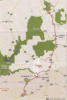
We left Gooseneck's State Park and set off for Moab on Highway 163 to Bluff, passing Mexican Hat (a pile of balanced rock in... you guessed it... a Mexican Hat shape) on the way.

Then we used Highway 191, passing through Blanding and Monticello before making it to Moab's River Canyon Lodge by mid afternoon. And then we JUMPED IN THE POOL!

Monday, 17 May 2010

Day 11 - Viva Las Vegas

So today Faith was really generous and gave us the latest start of the trip – 9am!!! This was deeply appreciated after our first night in Sin City as many of the lads (including Vicky) were busy collecting ‘top trump cards’ along the strip.


Las Vegas Strip from the Eiffel tower at Paris! Casino

Image from: http://touroncell.com/cart/images/Las%20Vegas%20Strip.jpg


Unlike most days there was no UON bombardment of the local supermarket, but instead a leisurely stroll around Las Vegas strip. The strip or Las Vegas Boulevard is around 4.5 miles long and has a habit of making things look closer than they are due to their size. We discovered this on many occasions throughout the day! As well as this compared to all of the other places we have visited before Las Vegas it was very rare that an American voice could be heard through the masses of people piling through the streets. It was almost possible that you were in another country outside of America, infact outside of reality!

Las Vegas has an attraction to people of all ages due to the activities which are available; however the mean visitor age is 47.7 years old. This was seen in the casinos where there were many old people playing the slots or roulette. This seemed surprising at first as through media, such as films Las Vegas is always seen as the city of Sin or in the case of ‘The Hangover’ a stag party location. Once in Las Vegas it is obvious that money is needed and at the end of the day what age range has money to waste?


A map of Las Vegas Strip

Image from: http://www.paylessvegas.com/img/vegas_strip_map.jpg


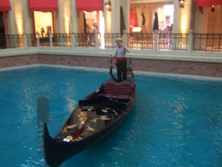
After eventually organising into groups we unleashed ourselves on the strip. First stop: the Venetian. This casino blew us away or rather, floated us away on a lovely gondola ride with a fake Italian serenading us with ‘That’s Amore’. Well, Mary-Anne and Luci did this while Danni and Scott got lost in the shopping plaza, who with their great sense of direction found the car park on the third floor instead of the exit! In fairness to Danni and Scott though the Venetian is designed to confuse you as it has a skyline inside that changes from daytime to evening throughout the day, so you are never quite sure where you are or what the time is!


Inside the Venetian Hotel where outside is inside.


Whilst on the gondola ride we were informed by the fake Italien man that the Venietian was built in place of Sands (this is what it sounded like) Casino where the rat pack always used to play concerts.


The fake Italien man on the inside gondola experience


After our little adventures in the Venetian we headed to the Mirage, which was themed around an oasis. The most amusing part of this was that it appeared that the flowers were fake as there was a lady dusting and cleaning them! However this is a sustainable approach for a city located in a desert where water is short. However, as information at Springs Preserve told us the day before, resorts are only using about 7% of the city’s water meaning that using methods such as fake flowers is helping reduce water usage even more. This is present in many areas of the strip including along the road where desert plants are being used which can handle a lack of water.


The Oasis in mirage which appeared to be made up of mainly artificial plants.


This sign was located outside resorts which were working in conjunction with the water authority.

At the Mirage you could go to the Secret Gardens where you could see dolphins and white tigers, yes that’s right dolphins and tigers in Las Vegas, where the dolphins don’t do shows they do ‘educational programmes’. This surreal experience was fantastic but at the same time quite disturbing as the animals didn’t really have large areas to live in… not compared to the size of the hotel anyway!


Entrance to the Secret Gardens where wildlife enclosure and dolphin habitat is located.


After the Mirage we decided to get some food (which was amazing!! Stuck on what to eat? Visit food hall in The Venetian!) and took a stroll down the strip towards New York New York. Luci was being snap happy, Scott was chatting up Elvis and Danni was feeling slightly alienated as she felt like she was a part of ‘A Bugs Life’ in Las Vegas because everything is so big and we are too little for the city.


Tall skyscrapers cover the strip enclosing you in making you feel similar to a bug.


By this point we started to appreciate the lazy American lifestyle of escalators in the street as our feet began to hurt, and we started to believe Faith’s wise words of ‘you will walk more in Las Vegas than you have so far on the trip’.


In street esculators to make crossing the road much easier and efficient.

Image from: http://mukerji.s3.amazonaws.com/wp-content/uploads/2009/04/dsc_0538-800x535.jpg


We eventually got to New York New York where we almost got lost in the casino as there were no maps!! It was interesting to see how bored most of the gamblers looked! Along with this gambling without an alcoholic drink in the middle of the afternoon was just not allowed. The most bizarre thing however was people smoking inside, yet another tactic to keep a person gambling for longer!


The skyline of New York New York Casino


We took a stroll round the streets of New York along with a look at the statue of liberty where we discovered the 9/11 memorial which was a come back to reality in a city built around make believe.


A quote from above the New York New York 9/11 memorial where t-shirts of service men had been layed out in respect.


After our experience of New York, which is ‘the best city in Vegas’ we started heading back up towards our hotel, which was good news for Luci and her camera. On the way we met a real life m&m and a member of Kiss with a removable tongue. (this was freaky to say the least!)

Overall today has been filled with A LOT of walking and adjusting to the fact that people do actually exist again. The Strip is mind-blowing, the size of the buildings and the themes are sensational. The tackiness and being in a make believe area in a sense, makes Las Vegas a fun place to be. Our exploration of the Strip in Las Vegas emphasised the fact that Las Vegas can be enjoyed even if you are not gambling. There are so many activities to be done and so many ‘cities’ to visit in the 4.5 mile strip that each place is a totally new experience. However when in Las Vegas it is advised that you have A LOT of money as there are so many places that entice you in and make you want to buy things, if you have will power you will be fine but if you like designer labels... well... good luck to you!


We have now crashed and burned in our hotel room and are just getting ready to go to the baseball game like true Americans... Wish us luck in figuring out all the rules!


Sound advice for visiting Las Vegas =]


Thursday, 13 May 2010

airport


terminal 2


30 minutes left.
lots of noisy dirty people in front of me.
i know them.
they have trashed this corner.
i may have to disown them now.

Las Vegas Terminal Two

After the 8th hour of sitting here waiting for the plane we have all become quite quiet...
After playing a rowdy shoe game, cards, throwing cups and botles in the bin and chanting UCN we are slowly running out of things we can do :-(
Boarding is in an hours time, most people are broke, and have spent their complimentary £15 dinner voucher (in Burger King).
We've had very wierd looks (especially mary-anne!) and Greg has finally got given the A-ok to fly home with us. Whoop!
Our new arrival time should be 4pm friday at Gatwick... Fingers crossed eh?

What would life be like without Geography!?

Love Mary-Anne and Josh

P.S. student services: i have evidence of syncronised swimming!

Zion to Las Vegas

The last drive ending at the city of sin

As the sun rose over Zion we little campers said goodbye to Utah, the towering Navajo Sandstone cliffs and stunning scenery.

What we were leaving behind :(


First stop WALMART!

This is where we all stocked up one last time before heading to the city of sin

Before entering the city that never sleeps, we took a detour to Springs Preserve (The old springs) which once upon at time supplied Las Vegas with the ever so precious H2O before it dried up and Hoover Dam took the honours. We gandered around the preserve watching videos, poking cacti and learning about the history of Las Vegas in a human and geological context.

In the Preserve there is a sustainability gallery which teaches visitors to live sustainably. Remember the quote campers.... "development that meets the needs of the present without compromising the ability of future generations to meet their own needs". (United Nations 2009)

It does this through interactive methods allowing all ages to participate in the learning experience. The things this includes are a video in a recycling truck and a driving experience whereby you can learn about how unsustainable cars are and the more energy efficient alternatives. Also one other thing we got excited about (well Emma did anyway) was the sustainable house and the fun ways of adapting your house to be sustainable. Our fun was cut short as Greg demanded (politely) that it was sadly time to leave.

The cool dustbin cart

A few interesting facts we learnt today:

• Las Vegas is Spanish for “The Meadows”
• Population of the Metropolitan District of Las Vegas is 1.95 million.
• Hoover Damn was built in two years and to those who have seen this immense mount of concrete can appreciate the ingenuity and hard work that went into this construction (Video in Ori-Gen Centre).
• 2 million gallons of water are conserved in Las Vegas each year
• 90% of Las Vegas water comes from the Colorado River

Upon exiting the old springs, Duncan decided to fuel up as Janet watched by forgetting that she had even less fuel than Big D and thinking that singing in the mini bus would make things all right. As Janet lagged behind students were thrilled at the opportunity\embarrassment of pushing a FORD minibus down the strip for all to see. Meanwhile bus 1, 93 and…… Chris's, were marvelling at the sites with their heads bopping and cameras flashing as they rolled down the strip in style (with fuel in their tank). Left to our own devices we entered the Flamingo Hotel and after writing this blog we are now ready for what the night has to offer.

The Flamingo Hotel that we are staying in certainly has a lot of history surrounding it. It first opened on New years Eve 1946, and its owner was none other than the ganster Bugsy Siegel. However it has been completely rebuilt so nothing remains of the original hotel/casino. The hotel is on the larger side with a huge 3,626 rooms and a large casino to match (Vegas.com 2010)

To sign off we leave you with this inspirational lyric from the Big man himself; Elvis Presley……VIVA LAS VEGAS!!!!

Emma, Rachael and Alice

References:
United Nations (2009) Report of the World Commission on Environment and Development: Our Common Future [online] Available from: http://www.un-documents.net/wced-ocf.htm [Accessed 16th May 2010]

Vegas.com (2010) Flamingo Las Vegas [online] Available from: http://www.vegas.com/resorts/flamingo/ [Accessed 16th May 2010]

Sunday, 9 May 2010

After a most excellent day off in Moab, which included rafting on the Colorado river (yay!), horse riding (Em, her horses name was Chism) and excessive drink (Tris and Jonny), we left at 6am (much to the boys dismay). Heading out of Moab and starting our long journey of 266 miles to Bryce Canyon National Park, we stopped off at Capitol Reef National Park.

Capitol Reef National Park


On arrival here, we headed straight to the the visitor centre to pick up our junior ranger programs and attend the "Watermark" orientation video, all about the formation of Capitol Reef.

Physical Geography

The video was very informative on the formation and continuing development of Capitol Reef. The waterpocket fold defines what the national park is. It has been 519 million years since the uplift of the colorado plateau, caused by the destructive plate boundary between the North American plate and the Overlying Pacific plate. This caused a monocline, "step" in the rock formation, with rocks overhanging lower levels, creating a fold.
The Waterpocket fold however formed around 50-70 million years ago, and is so named for the continuous erosion of the different layers (stratifications) of rock. It forms when water erodes away rock forming a basin.
In Capitol Reef, these basins are very common in the fold, giving it the name Waterpocket Fold.

One of the most famous parts of Capitol Reef are the Fremont Petroglyphs found on the rock face walls. The Fremont Culture lived there from about 700 until 1250.


Tourism
Capitol Reef National Park presents huge domes, spires, monoliths, twisting canyons and arches. All these scenic natural features attract tourists all year round. Capital Reef National Park has a visitor centre which has a gift shop selling souvenirs, a museum for people to learn about the history and wildlife of Capitol Reef. Also there is a theatre which provides a vital resource for teaching tourists about Capitol Reef, how it was formed, what there is to see such as pictographs and mazes etc.
Capitol Reef is open all year round there is a campground and sources such as food stores, gas stations nearby. A Junior Ranger badge can be achieved by tourists by learning about the area and completing a workbook full of tasks. Guided trails are offered and you can pick fruit from the orchids to eat there or pay to take some away. There are scenic drives available, lots of hiking trails, bicycle routes and scenic views all round available to tourists.

Resource Management

Capital Reef National Park integrates, like most national parks the use of all natural, historical and cultural elements whilst being as sustainable and economical as possible. Part of this is the Junior Rangers Guide, within the guide it tries to educate the Junior Ranger on how to keep the park clean, giving information on how dangerous cigarette butts and rubbish is to both the animals and environment within the park.
Also Capitol Reef only waters one section of its park, the rest is down the natural movement of the elements, this watering occurs at the Orchards, the Orchards are part of Capitol Reefs history and heritage, with settlers starting to grow fruits there over 100 years ago.
Federal Law decides that all natural, historical, archeological and cultural resources are protected and that there is a hefty punishment if this law is broken.
Other resources within the park are picnic areas, restrooms, drinking water and specified grills cutting any hazard of excess waste and fires, with extra fees for the Orchards and camping the Park makes money to keep its maintenance at a high standard looking after all the features within its boundaries.

Bryce Canyon National Park

Then it was on the final leg to Bryce Canyon National Park. This park was the highest one we visited, at 9600 ft.

Physical Geography

Most of the Canyon is made up of landforms called "hoodoo's". These were formed from fins which developed during the process of uplift of the Colorado plateau and the fracturing of crust. The "hoodoos" are made up primarily of Claron Formation which is a silty and sandy limestone. from the uplift, vertical cracks (joints) were made. These joints were block fins, and were weathered first, forming cracks in the fins. The more resistant layers of rock protected the softer rock from weathering. The harder Wasatch limestone formation left horizontal ledges as the fins eroded. The fins disintegrated due to excessive erosion, which left behind slender remnants of the original block of limestones. These remnants are testimonies to the work of water in the arid landscape that is Bryce Canyon National Park (display at Bryce Canyon National Park visitor centre museum).

Tourism

Bryce canyon National Park offers visitors grand views from the eastern edge of the Pausaygunt Plateau in Southern Utah. The visitor centre is open all year round, with a natural history museum and gift store. A video program is shown daily in the auditorium teaching people about how it was formed and information about the area. There is a rustic style dinner open from april to october. There is a general store, guided and self guiding tours and horseback tours available. There are a variety of hiking trails and lodging available. Camping grounds are available and Bryce Canyon Spectacular scenery to keep attracting tourists.

Resource Management

Bryce Canyon adopts the same attitudes towards its natural, historical and cultural features just like any other national park and just like Capitol Reef it does everything within its power to provide a good, safe and sustainable environment for its visitors, this includes among others a shuttle bus run. Using a shuttle bus run can cut down on fuel consumption, pollution and the building of anymore unnecessary car parks.
Other resources at Bryce include trails for cycling, hiking and walking to really open up the experience for its visitors whilst being as environmentally friendly as possible to stop any damage being done to its features. Also covering religious services due to the historical Mormon heritage and holds services at Bryce Canyon Lodge.
There is an RV park so visitors can stay on their own accord and shower and laundry areas which also provide a useful yet sustainable service for anyone involved.

Personal Reflections

I thought that it would have been nice to actually have seen more of Capitol Reef as we did not really walk around or see much of the National park, although we had the debate there which was interesting. Bryce Canyon was the best part of the day with amazing views and a nice walk down into the canyon and back up. Although we did miss the chance to get a Junior Ranger badge due to someone messing up the times Greg.

Although we did not have a lot of time at Capitol Reef we were able to have a debate on the effects of tourism on nearby town Moab, this was educational and fairly fluent for most involved becoming heated at times with both opinions and facts having its fair share. At this point I had removed the pen from my face, after Kate the ranger had seen it.
Bryce Canyon like everything else that has been seen on the trip was amazing to see and had interesting history and geological facts, although there probably could have been a little more to be learnt there.